2 Jul 2020
Well, the day we have been waiting for has finally arrived. A quick, but good nights sleep and its time to get moving. Up at a reasonable time, breakfast done, time to get the bike packed and us ready.

After the obligatory selfie to mark the start of our journey we are off… It was actually really tough to head straight into Winchester to the ‘start point’ but I steeled my resolve, stayed focused, and rode past our favorite meandering routes this morning :-).

I didn’t really have any expectations on the first leg over to Harpers Ferry, but we were pleasantly surprised. Just outside of Winchester the road got to be quite nice, old homes and farms with plenty of twists and turns to keep it interesting.

I don’t think we have ever been in Charles Town before so it was enjoyable to see several really nice old homes presented themselves. We drove by this place then decided to pull back around and take a closer look. So glad we did. In addition to being pretty there is a significant civil war historical backdrop here.
In the parlor of this home on 17 Sep 1864 General Ulysses S. Grant issued his famously short order to General Phillip H. Sheridan to “Go in!” (and raze the Shenandoah Valley). On 19 Sep Sheridan defeated Gen Jubal A. Early at Winchester then over the next weeks carried out “The Burning”, destroying barns and mills in the valley.
Reading the account I was reminded of our visit to the Grandstaff/Edinburg Grist Mill restaurant and museum, one of the few mills spared, I’ll have to go back and remember that story some time and create a post here…
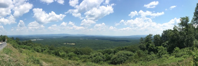
Lots of states already today; West Virginia, Virginia, West Virginia, Maryland, then Pennsylvania. This is just about as far north as we got. We stopped to take the vista picture below, and had to wonder, was the location Providence? Perhaps? I sure could use a cut! :-). The view was certainly stunning. Hot as the dickens, but very pretty.
The day progressed well, with many many twists and turns along the way. Later in the afternoon we started to climb a bit in elevation, the sun lost some of it’s ferocity so the temps became more pleasant. The snippet of map below, as we approached our stopping point for the night, really illustrates the day well.

Looking back at this map screen shot reminds me of that loop around the arm on the lake just right of the Highway 46 legend… it was one of those long sweepers that just went of forever. Ahhhh, so nice…..

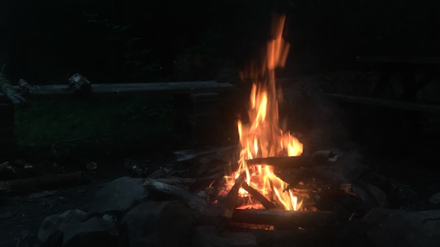
Our lodging for the night was at a campground right on U.S. Route 50 just outside of Mount Storm. This area is really in the boonies, not a lot of options for overnight stays. The Abram’s Creek campground is very nice, spread out and quiet, with the creek right below the cabin. Lots of tent sites too, definitely a place to come back to if we are in the area again.

After a picnic dinner by the creek and some time around the fire it is definitely bed time. Actually seems a little funny to be sitting by the fire after sweating all day, but it is a little cool this evening so it does feel good, and camping with out a fire just isn’t right! So, a long, very good first day out, we will definitively sleep well tonight.
Enjoy the route map below. Explore the roads and additional photos along the way… As always I hope this encourages you to get out there and explore, perhaps around here or where ever you find your self. And please comment if something comes to mind, love to hear from you.
I love it! Seems like y’all had a great time.
Sure did Nick, as mentioned it was a touch warm but that just means ride a little faster to cool down right ;-).
Thanks for sharing your refreshing trip with us! I personally appreciated the virtual experience, well capturing your narrative and pictorial journey!
Dave I’m so glad you are able to follow along – it’s a bit of work but I love the idea of sharing the experience in hopes that perhaps it will open someone up to a new thing and encourage others to find there way out to what ever adventure suites them well…
I’m impressed, I have to admit. Rarely do I come across a blog that’s equally educative and entertaining, and without a doubt,
you’ve hit the nail on the head. The problem is
something which not enough people are speaking intelligently about.
I am very happy I came across this in my hunt for something regarding this.
So glad you enjoyed it! I suspect the reason for sorry content is that those ‘writing’ are not the ones ‘doing’. Just for fun I clicked on a link about a subject I have some experience and knowledge about. It’s always good to pick up some additional insight and maybe a tip or trick right? The article was absolutely awful. It was very clear that the person writing had never ever done the thing they were trying to describe. What’s sad is the idea that someone without knowledge and trying to learn might read it and think they are getting good advice! I haven’t done much here for a while, your comment encourages me to add a little more soon. Thanks! 🙂